From Sylvan Beach on the east to Brewerton on the west end of the lake is only 22 miles. Broad Reach can easily do 7 MPH under full power. On a calm day the crossing should have taken us about 3 1/2 hours. We left the marina around 8 AM and headed out into the lake. As we powered out past the breakwater at Sylvan Beach there were a few white caps in the distance, but nothing like the previous evening. There was however a steady 4 foot swell coming down the lake from the west. The wind was steady out of the west, and we had to power the boat directly into the wind and waves. After an hour of pounding into the chop we had only made about 2 miles of progress. The normal passage across the lake follows the buoys down a centerline from southeast to west. This avoids all of the shoals and shallow water on the south side of the lake.
By the time we pulled even with Lewis Point, the wind began to get stronger and suddenly changed direction. It quickly built to a steady 20 MPH and shifted out of the southwest. The change in direction meant that the tops of the westerly waves were being sheared off at an angle that was coming across our port bow. The spray was drenching the deck. We soon were pitching and yawing violently with a motion that rolled the boat from side to side, as well as bow to stern. The mast stayed firmly secured to the deck, but we were concerned about how much stress the temporary stays could handle. We talked about turning around to run downwind back to Sylvan Beach, but that would expose us to the same chop from the stern. We made a decision to navigate past the shoals and towards the southern shore. If we could get in close enough to the new direction the wind was coming from, we could at least reduce the pitching of the boat.
As we approached the southern shore, the cross chop got stronger. We started calling on the VHF to see if any of the marinas on the southern shore had enough depth for us to safely make harbor. We tried hailing Lakeport Marina, but got no response. When we were just a few hundred yards off Bushnell Point, the chop lessened a little, and we finally felt we could continue up the lake without shaking the boat and crew past their limits. There were a few tense minutes of consulting the GPS as we tried to cross just north of Lakeport Shoal, but without going too far back out into the center of the lake.
By the time we made Shackelton Point at noon, we were halfway up the lake. The decision to hug the southern shore proved to be a good choice. The winds began to lessen and the chop reduced to 2 feet. The winds were still out of the southwest but there was not as much fetch for the wind to build a significant cross chop. We decided to use the two islands in the middle of the west end of the lake as cover. We reasoned that there should be a wind shadow in the lee to the north of Dunham Island that would protect us from worst of the wind. The only catch was that the approach to the northeast end of Dunham is guarded by lots of shoal water. The marked channel between the shoals is only 500 feet wide. We set a new bearing on the GPS and headed back out into the center of the lake on a NNW heading. We found the Red Mark 130 just shy of Pancake Shoal.
By the time we had negotiated the narrow channel into the lee of the island, the wind suddenly died. It was 2 PM when found some breathing space. By the time we had passed Dunham and Frenchman Islands, we were finally able to get the camera out for a photo. The temporary stays had done their job, and the rig had been fully proven. The chop we had been fighting all day was gone.
We were exhausted and ready to be off the lake when we saw the bridge for Interstate 81 in the distance. We knew we had made it to Brewerton. It only took us 7 1/2 hours of pounding to make it there. As we swung under the bridge, the winds that we had fought all day died out completely to a flat calm. Timing is everything.
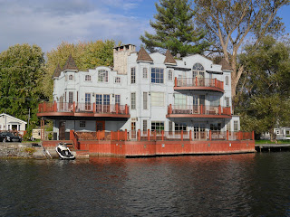
As we made the turn onto the Erie canal again, we saw this unique waterfront home. We both wished we had spent the day lounging on their sundeck.
Pulling up to the dock at Brewerton Boat Yard we both decided that we needed some scotch and warm food in that order. The Waterfront Tavern gave us a great view of where we had just been. It was astounding to see how flat the water on the lake was as the sunset turned the water a golden yellow.
The forecast for the next day was for more wind and rain, with the temperature falling into the 40s.
Predicted winds were 20 MPH with gusts above 40 MPH. How difficult could that be down in the protected valley through which the narrow little Oswego River runs? Nothing like the day we had just gone through.....we hoped.


No comments:
Post a Comment